Home & Synopsis/Status Reports Purpose & Method Who was Carl Sharsmith? Why name a Yosemite feature for Carl?/Origin of Proposal WHICH FEATURE SHOULD BE NAMED FOR CARL? How can a feature be named for Carl? Summary of Supporting Statements Contacts/Resources Webmaster Search Form
Use of this site means you accept its terms and conditions.
Go to "More photographs of Informally-named Sharsmith Peak".
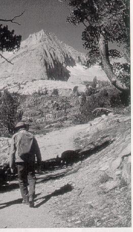
Carl on the trail, from O'Neill, John Carroll and Elizabeth Stone, from Tioga Tramps: Day Hikes in the Tioga Pass Region, permission for use requested 4/26/06.
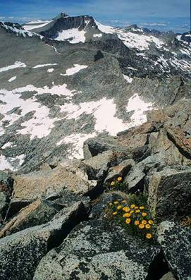
Photo from proposed Sharsmith Peak summit,
looking north-- photo by Chris Runner;
permission for use granted 10/03/07.
Which feature should be named for Carl?
by Bill Jones, former Chief Park Naturalist, Yosemite National Park
Why a landscape/map feature for Carl versus a facility name?
Names of landscape/map features endure; names of man-made facilities or programs end with demise of the named facility or program if not sooner. The landscape was Carl's forte; man-made facilities he largely shunned, in keeping with his live-so-lightly ethic. The very naming process for a landscape/map feature assures permanency. And it is anticipated that the importance of Carl's work in the Sierra will endure beyond the life of any man-made facility or program, as have the works of Josiah Dwight Whitney, Galen Clark, John Muir, Clarence King, Ezra Taft Benson, Chief Tenaya, Forrest Townsley, Ansel Adams, and others, the works of all of whom are recalled by their names on maps.
Criteria for the landscape/map feature to be named for Carl Sharsmith
Criteria to apply in selecting a landscape/map feature to be named for Carl include the following:
the feature should be currently unnamed or in need of being renamed and has a good argument for being named or renamed
the feature should be in the Tuolumne Meadows region of the High Sierra of Yosemite National Park, where Carl is most associated
the feature should be an area above tree-line that supports high altitude flora, Carl's main botanical interest and the field of his greatest scientific contribution.
the feature should be prominent, but not imposing, as Carl was not
the feature should be one Carl has endorsed, or one that he might have found appropriate for endorsement.
the feature, if possible, should not be within designated wilderness (in order to avoid possible conflict with National Park Service, U.S. Forest Service, and Board on Geographic Names policies regarding naming features in wilderness)
Candidate landscape features
The peak that has come to be informally called Sharsmith Peak by the Yosemite Association and others has its summit area above the tree-line in the arctic-alpine life-zone of plants. The summit area is primarily loose granitic rock varying in size from irregular angularly shaped blocks to small sand grains of crystals so that boreal plants may obtain footholds, moisture, and protection from wind in sheltered sites. The peak is located at the crest of the Sierra Nevada on the eastern border of Yosemite National Park, which is also the eastern border of the legislated Yosemite National Park wilderness. The peak is at latitude N37º 56.194' and longitude W119° 17.615'. This point is labeled 12,002 as shown on the 1956 Tuolumne Meadows, Calif. 15 minute topographic quadrangle map published by the U.S. Geological Survey. This point is located on the Sierra Nevada crest between White Mountain (south of Mount Conness) and Gaylor Peak (north of Tioga Pass). The 1994 Tioga Pass, CA topographic quadrangle map published by the U.S. Geological Survey covers 7.5 minutes of the above area and shows this same summit to be just over 12,000 feet high but does not label it. (Topo USA mapping software, version 6.0 from DeLorme, shows the peak at 11,939 feet altitude.) The Yosemite area west of informally-named Sharsmith Peak is managed by the National Park Service of the Department of Interior; this region is to be maintained in its present wilderness condition. East of informally-named Sharsmith Peak is Inyo National Forest, managed by the U.S. Forest Service of the Department of Agriculture. Lands here in the forest are designated the Harvey Monroe Hall Research Natural Area. Purpose of the Hall area is to preserve ecological integrity, genetic diversity, a baseline for measuring ecological change, and to educate; these purposes relate directly to Carl's focus in alpine botany and his wish to maintain natural areas for plants. In order to avoid human impacts, the Research Natural Area does not encourage public use; it is envisioned that formally naming informally-named Sharsmith Peak would add little public use to the Research Natural Area because the informal name Sharsmith Peak is already in use for the feature. The point is also on the border of Tuolumne County (to the west) and Mono County (to the east). (Scroll to page bottom for links to maps of informally-named Sharsmith Peak).
This same point, Peak 12,002 has also been informally called False White Mountain Peak and False White by ski mountaineers. Thus, in different communities of users, the peak has four names in use: Peak 12,002, Sharsmith Peak, False White Mountain Peak and False White.
[A curious semantic issue arises: because the informally-named Sharsmith Peak lies at the border between the park and the forest: Does this put the peak in the park or in the forest, or both, or neither? To what does the word "peak" generally refer? Just the summit of a mountain itself or to a portion of land surrounding that? Is informally-named Sharsmith Peak in the wilderness or in the forest, or in both, or neither? It could be hoped that such questions would not seem important in view of overriding values that support the naming.]
Because almost all the Yosemite High Sierra is in legislatively designated wilderness and because the little that is not is along roads and otherwise not in the alpine zone, few other peaks besides the informally-named Sharsmith Peak could meet both the desire to have an alpine peak named for Carl and the Board's policy to avoid naming unnamed features within wilderness.
Mammoth Peak, however, is another Yosemite National Park feature that has been considered to be named for Carl. An argument in favor of renaming this feature is to reduce confusion of it with Mammoth Mountain, on the border of Mono and Madera Counties, location of the ski area near Mammoth Lakes, California. Mammoth Peak is the mountain that stands prominently south of the Tioga Road at the north end of Kuna Crest. The Lyell Fork of the Tuolumne River is on its west, and the Dana Fork of the Tuolumne River is on its north. It is labeled Mammoth Peak on the 1956 Tuolumne Meadows, Calif. 15 minutes topographic quadrangle map published by the U.S. Geological Survey; its height is labeled as 12,117 feet thereon. The subsequent 1994 Vogelsang Peak 7.5 minutes topographic quadrangle map published by the U.S. Geological Survey shows this same summit to be over 12,080 feet high. Peter Browning's Place Names of the Sierra Nevada, 1986, (page 136) reports the peak was first named on the third edition of the Mt. Lyell 30 minute map of 1910. The area of this feature is entirely within Yosemite National Park and within the legislated Yosemite National Park wilderness, and so is managed by the National Park Service of the Department of the Interior.
Georgia Stigall reported Carl's preference for Mammoth Peak,
I did have a conversation with Carl about this topic after some folks asked me about his views on it. I asked him directly, "If a mountain were to named after you which one would you choose? " And he responded with Mammoth Peak, because it overlooks Tuolumne Meadows and is near Mount Dana and Dana Plateau. [e-mail from Georgia Stigall to Owen Hoffman and Bill Jones dated 12/1/2003].
Bob Fry also has noted that Mammoth Peak was one Carl had suggested be renamed for him when asked about this topic.
Dick Ewart and Margaret Eissler also report Carl's mention of Mammoth Peak as one to be renamed for him, as reported by Len McKenzie, who notes that,
[Dick Ewart (Yosemite ranger-naturalist for some 30 years and instructor in Yosemite Outdoor Adventures of the Yosemite Association)] told me (some time ago now) that he, Margaret [Eissler] and Laurie Lawrence spent three days and two nights on Peak 12,002 in 1989 and that, although [Carl] would have preferred other peaks already named, particularly Mammoth Peak, he was pleased and honored with the choice of Peak 12,002. They camped beside an alpine meadow about 100 feet below the summit, and he considered it a 'premier spot'. That peak was one he had never climbed (hard to believe about Carl), and it was one place he wanted to see before he died, according to Dick. [e-mail dated 4/15/2006 from Len McKenzie to Bill Jones.]
Len McKenzie also reports regarding that same trip,
[Margaret Eissler (in 2006 the District Naturalist at Tuolumne Meadows with experience there since a child)] "said [Carl, on the above-mentioned 1989 trip] had a botanical interest in the meadow bog but didn't find anything new. She also said he preferred that Mammoth Peak be renamed for him but 'didn't object' to 12,002." [e-mail dated 4/15/2006 from Len McKenzie to Bill Jones.]
A subordinate summit area of Mammoth Peak has also been suggested as a candidate to be named for Carl. This spot is within legislated wilderness.
Peaks at the south end of Kuna Crest and a mile from Mount Lyell were in the late 1970s and early 1980s under consideration to be named for Carl, too, during a naming campaign led by Henry Berrey of the Yosemite Natural History Association (now Yosemite Association). (See "Why name a Yosemite feature for Carl?/Origin of Proposal" ) These, however, are within legislated wilderness and appear not to have been active candidates for decades.
The unnamed summit at the head of the Dana Plateau has been considered.. This spot is not within and does not abut Yosemite National Park, the locus of Carl's Sierra work. so likewise is not favored by this proposal.
Electra Peak (Electra Peak is a few miles south of Mount Lyell, today surrounded by legislated wilderness) was considered to be named for Carl as well, according to Tom Bopp,
I remember Carl would have liked Electra renamed for him, but he said you had to be "good and dead" before they'd name something after you..." [e-mail from Tom Bopp to Bill Jones dated 05/25/06]
Michael Ross has revealed how the final selection was made of the peak to be named for Carl:
Toward the end of his [Carl Sharsmith’s] life a group of us younger naturalists asked Carl which feature he would like named after him. We suggested the unnamed 12,002 foot high peak north of Gaylor Peak. Carl was pleased with the suggestion, especially since there is a rare meadow ecosystem below to the south of the peak, which contains a relictual population of an artic alpine flower. Since that time the peak has been called Sharsmith Peak by a large number of people. [letter of October 25, 2006, to Bill Jones]. See also "How Peak 12,002 became known as Sharsmith Peak, email from Michael Ross dated November 5, 2006"
When Bill Jones (once Tuolumne Meadows District Naturalist and
later Yosemite Chief Park Naturalist) last
saw Carl, after following Carl on a nature walk, Bill asked Carl whether a peak
had been identified to be named for him. (This was on August 26 of 1991.) Carl
said that unnamed peak 12,002 was to be proposed, according to his
understanding. Carl reported that some of the park naturalists had suggested
this peak to him as the appropriate one to bear his name. At that time he did
not mention any other feature as a candidate to bear his name. The suggestion to
rename Peak 12,002 as Sharsmith Peak had gelled by now. Carl appeared to Bill at
that time to appreciate the intent and to support the selection. Bill at the
time made a record of this oral communication, with no idea he would become
active over a decade later in formally proposing the name.
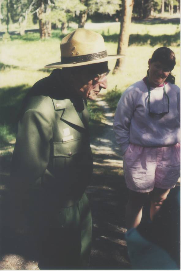
The photo at the right of Carl was taken on his nature walk
of August 26, 1991, after which he discussed with Bill Jones that some of the
Yosemite naturalist staff had suggested unnamed Peak 12,002 be proposed to bear his
name.
Photo by Penny Kerr.
Use of the Name Sharsmith Peak and Relation to Carl Sharsmith
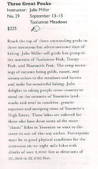
Julie Miller has used the informal name Sharsmith Peak for a guided hike she led to the proposal summit, and this name was published by the Yosemite Association in its 2002 Yosemite Outdoor Adventures brochure noted as follows:
Three Great Peaks...Reach the top of three outstanding peaks in three strenuous days of hiking. Julie Miller will guide her group to the summits of Tuolumne Peak, Tenaya Peak, and Sharsmith Peak. [see partial copy of printed brochure page at left].
Miller also gives talks relating experiences with Carl, and according to the above-cited brochure, had at that time worked in Yosemite since 1988 and manages the interpretive program for the Yosemite Concessions Services, with experience as a Yosemite bear technician.
Dick Ewart, Yosemite ranger for 30 years, says
I believe it was 1988 when I helped Carl hike up to 12,002, which we rangers all referred to as 'Sharsmith Peak [see statement of October 10, 2006].
Beth Pratt, Vice President of Yosemite Association, notes,
Although Sharsmith isn't the official name for the peak, apparently it is the familiar name used by park insiders. [from e-mail dated 11/5/2003 to Bill Jones].
Beth Pratt also posted this note on her website Beth's Excellent Adventures at www.bethpratt.com:
Regarding informally-named Sharsmith Peak, John Carroll O'Neill and Elizabeth Stone O'Neill write in Tioga Tramps, on page 26 (published 2002 by Albicaulis Press of Groveland, California),
There is an interest in naming this mountain as a memorial to Yosemite's famous ranger-naturalist, Carl Sharsmith. George Durkee, editor for the Sierra Nature Notes website for the Yosemite Association, includes this note on that website:
Many Yosemite locals have long called Peak 12,002 ...along the Sierra Crest and just north of Tioga Pass, Sharsmith Peak.
"Here’s looking north along the
Sierra Crest from Sharsmith Peak toward Mt. Conness and North Peak. "
reference on Super Topo Forum: exits
posted August 19, 2007 by TM Jesse.
Wikeipedia, the Free Internet Encyclopedia has an entry on Sharsmith at http://en.wikipedia.org/wiki/Carl_Sharsmith which includes this statement under Legacy: "Sharsmith Peak, informal name for Peak 12002 in Yosemite National Park; proposed official name," with a link to the current website.
In Scree of September 2006, publication of Peak Climbing Section of Loma Prieta Chapter of Sierra Club is this item, again by Dan Anderson, winter mountaineer.:
The April 1995 issue of Scree has an obituary of Dr. Carl Sharsmith, the beloved ranger-naturalist of Tuolumne Meadows in Yosemite. He entertained and educated almost every summer in Yosemite and taught at San Jose State the rest of the year. There is a proposal to name a peak after him, Peak 12002 south of White Mountain Peak. The details are at http://www.name4carl.org/ -- Dan Anderson
The above-referenced Scree for April 1995 (Vol. 28, No. 4) carries an early proposal by Laura Sefchik for naming Sharsmith Peak:
Like Muir and Adams, Carl will have a peak named for him soon. Hopeful1y it will be the Tuolumne Meadow’s region peak, Peak 12,002, his “sundial.”
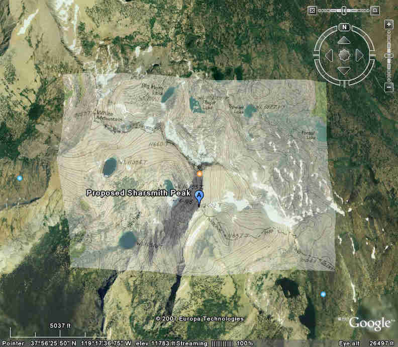
A search in the computer program Google Earth locates "Proposed Sharsmith Peak" at the label 12,002 of the U.S.G.S Tuolumne Meadows topographic map (see adjacent map). A similar search did not result in a location for False White or False White Peak.
An entry in the 2008 events guide of the Bristlecone Chapter of the California Native Plant Society follows (see www.bristleconenps.org):
August 23, Saturday. Sharsmith Peak. Leaders: Cathy Rose, Sherryl Taylor. The name Sharsmith Peak has been proposed for a mountain above the Gaylor-Granite basin on the edge of Yosemite National Park presently known as "12,002." Please park just outside Tioga Pass, NOT in the Gaylor Lakes trailhead lot, and we'll walk in to the trailhead for the moderately-strenuous hike to the summit with spectacular Yosemite views. Cathy Rose, a student of legendary Yosemite botanist Carl Sharsmith, will share memories of Carl as we enjoy the subalpine and alpine flowers and birds. Meet at Tom's Place at 8:00 for car-pooling, or be outside the pass by 9:00. Bring lunch and water, and expect a full day's hike. Please call Sherryl Taylor (760-924-8742) for more information.
A search on the internet for the names False White, False White Mountain, and False White Mountain Peak found about four website entries, all pertaining to winter ski trips there. Another use occurs in print in Sierra Heritage for February 2005, "False White screams down the blank open slopes of a peak just northwest of the [Tioga Pass] resort." As noted, the ski mountaineering community endorses the name Sharsmith Peak.
A trip announcement in Yosemite Winter 2008 lists a hike Aug 21-24 to "Tuolumne Elite Summts...Dayhikes up three choice peaks (Sharsmith, Tenaya, Tuolumne) with learning and enjoying for mind and body."
Form of the name Sharsmith Peak
The form chosen for the name of the feature proposed to be named for Carl is Sharsmith Peak. Other possible forms include Sharsmith Point, Mount Sharsmith, and Sharsmith Mountain.. Another form is to add the first name, as Carl Sharsmith Peak, Carl Sharsmith Point, Mount Carl Sharsmith, or Carl Sharsmith Mountain, but policy of the Board on Geographic Names is to discourage use of more than a surname (although there are exceptions in the Sierra Nevada including Mount Ansel Adams, Mount Clarence King, and John Muir Trail.)
Conclusion
Several mountain peaks have been considered to be named for Carl, and Carl endorsed most if not all of them. After some effort to find out how the current naming proposal centered on what has come to be informally-named Sharsmith Peak, it remains unclear just how this summit finally won out. Nevertheless, this proposal prefers it because it best meets the criteria for naming set out at the start of this analysis, and so is judged to be the most likely of all considered to be approved by the Board on Geographic Names:
The informal name Sharsmith Peak has been used for this otherwise unnamed summit.
The summit is not now formally named.
This spot was endorsed by Carl and Carl did visit its lower slope.
Peak 12,002 stands alone on the crest of the Sierra Nevada, is of alpine character, and is in the Tuolumne Meadows region of Yosemite National Park.
Peak 12,002 is not within legislated wilderness, but at the eastern border of same. (Board policies generally oppose naming features within established wilderness; Peak 12,002 is the only peak considered for naming for Carl that is outside legislated wilderness.)
Changing names that are already established, such as that of Mammoth Peak, is not favored by Board policies, and changing the long-standing name Mammoth Peak could lead to greater confusion than might currently exist between the Mammoth Mountain farther south and the Mammoth Peak in Yosemite.
A hike to the summit of informally-named Sharsmith Peak
John Carroll O'Neill and Elizabeth Stone O'Neill describe the hike to informally-named Sharsmith Peak in Tioga Tramps, pages 26-27 (published 2002 by Albicaulis Press of Groveland, California):
Climbing it from Tioga Pass is a fairly strenuous full-day, mostly cross-country ramble. [Details of route are given, with notes regarding clumps of whitebark pine, big rocky talus]...Where it seems nothing would grow, yellow ivesias and crimson rock-fringe bloom among bright blue lupines and penstemons...The final ascent, though not much more than a couple hundred feet, is no longer a walk-up, but a clamber...to the very small final top...A wonderful view in all directions awaits, especially of neighboring White Mountain with the peak of Conness just beyond. A surprise and delight is finding large-flowered alpine gold growing among the weathered summit rocks.
U.S. Geological Survey Maps of Informally-named Sharsmith Peak
Go to Map of Yosemite National Park showing general location of informally-named Sharsmith Peak at Yosemite National Park/Inyo National Forest border.
Go to Portion of 15-minute 1956 map "Tuolumne Meadows, Calif. Quadrangle" (U.S. Geological Survey) showing location of informally-named Sharsmith Peak. This map shows the number 12,002 at the peak's location.
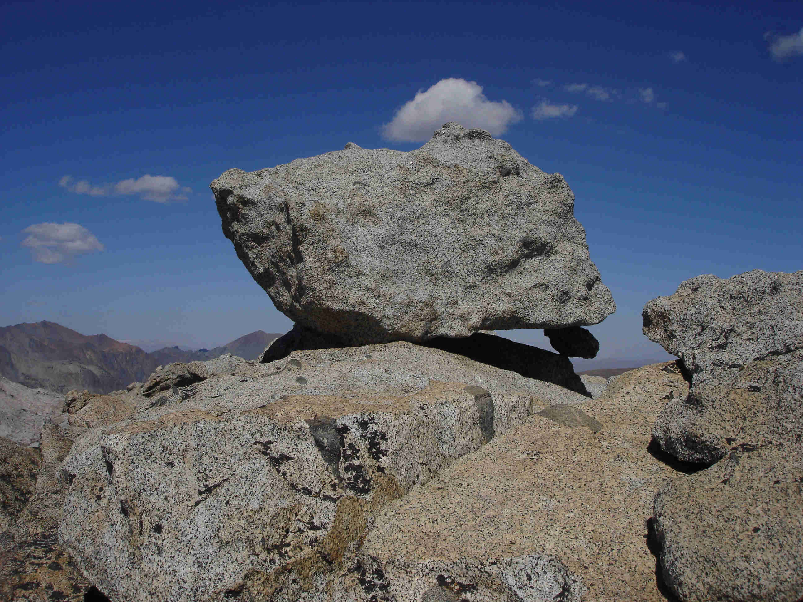
Summit block, Sharsmith Peak. Photo by WRJones 09/27/08
This "Which Feature Should Be Named for Carl" page last modified 10/15/2008: \name4carl\.n4ccritr.htm.
Home & Synopsis/Status Reports Purpose & Method Who was Carl Sharsmith? Why name a Yosemite feature for Carl?/Origin of Proposal WHICH FEATURE SHOULD BE NAMED FOR CARL? How can a feature be named for Carl? Summary of Supporting Statements Contact/Resources Webmaster Search Form